Browse our upcoming training courses in the calendar below.
QGIS Modeling – OPENGIS.ch
Description
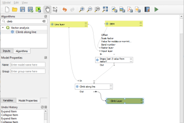
Mit der graphischen Modellierung in QGIS lassen sich mehrere QGIS-Werkzeuge in einem logischen Ablauf kombinieren. Dank der visuellen Gestaltung können Anwender:innen ohne Programmierkenntnisse Automatisierungen in QGIS …
QField Jump-start – OPENGIS.ch
You want to start collecting field data but never worked with a GIS before? You are a passionate QGIS user and would like a jump start your fieldwork setup? You are a senior GIS manager and would like to optimize your teams’ mobile data …
QField Workshop – OPENGIS.ch
How to become a superuser in QField You’ll not only be able to handle the app perfectly but also know how to set up a project to explore all the possibilities that QField offers. Prepare the optimal conditions for your field work and …
INTERLIS Crash Course Webinar – OPENGIS.ch
Description The goal of this crash course is to introduce “complete beginners” to INTERLIS. After the crash course, participants will know what INTERLIS is, how it is used, how to read a model, and how to find their way around it. They will …
QGIS ModelBaker – OPENGIS.ch
Description Nach Abschluss des Kurses kennen die Teilnehmer:innen alle Funktionen vom QGIS Model Baker und können INTERLIS Modelle in der Datenbank abbilden und Transferdateien importieren und exportieren. Ausserdem wird eine Einführung ins …
QGIS Basic – OPENGIS.ch
Description Nach Abschluss des Kurses kennst du die wichtigsten Funktionen von Open Source GIS QGIS Desktop, kannst Daten importieren, analysieren, eine Karte mit professionellem Layout erstellen sowie Objekte mit Attributen und …
QGIS Advanced – OPENGIS.ch
Description Nach Abschluss dieses Kurses kannst du komplexe Projekte mit QGIS umsetzen. Du kennst Werkzeuge für die effiziente Sichtung, Bearbeitung, Erfassung und Darstellung von geographischen Daten. Du kennst Eigenschaften von …
PostGIS with QGIS (on request) – OPENGIS.ch
Unlock the power of spatial databases in QGIS.
This hands-on course dives into the integration of PostGIS and QGIS, enabling efficient, scalable, and collaborative geodata management. Ideal for GIS professionals, analysts, and developers, …
PostgreSQL/PostGIS Administrator – OPENGIS.ch
The course is aimed at PostgreSQL users who want to expand their administrator skills. Various approaches are explained to optimize database usage and practiced through different examples.