Jul 7, 2024
Rapid Mapping the Ticino Floods and Landslides with QField Rapid Mapper – OPENGIS.ch
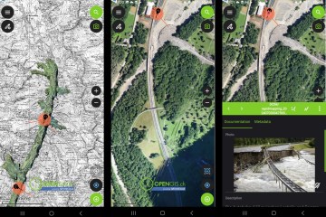
QField Rapid Mapper is a project for the QField mobile app, which allows emergency responders, civil protection, military, and citizens to…
Read More →
Stay updated with the latest QField news, releases, tutorials, and insights from the field data collection community.
QField Rapid Mapper is a project for the QField mobile app, which allows emergency responders, civil protection, military, and citizens to…

We are proudly celebrating our 10th anniversary , a significant milestone that marks a decade of innovation, collaboration, and success in…
It’s an exciting year for our company, and we are thrilled to share some amazing updates and a special announcement with you today. Our…

With the current release of the QField Series 3 , the significance of forests is reflected in the naming, underscoring the importance of…

**MEET US AT THESE UPCOMING EVENTS ** Calling all geo-enthusiasts! We’ve curated an exclusive list of must-attend events for you. These…

Swiss elevation profiles Get high-precision elevation profiles in QGIS right from Swisstopo’s official profile service, based on swissALTI3D…
Während der Pandemie bemerkte man, wie effizient man eigentlich remote kann, wie produktiv Meetings per Videocall sein können und wie gut…

This blog post will introduce QField’s brand new plugin framework and walk through the creation of a plugin to support bird watchers in need…

QField 3.3 has been released, and with it, we are proud to introduce a brand new plugin framework that empowers users to customize and add…

We are thrilled to announce that theBest of Swiss AppsEnterprise winner 2022, QField, has been officially recognized as a Digital Public…

Das PostgreSQL Connection Service Filepg_service.conf ist nichts Neues. Es existiert seit einiger Zeit und vermutlich hast du es auch schon…

At OPENGIS.CH, we’ve been working lately on improving the DXF Export QGIS functionality for the upcoming release 3.38. In the meantime,…